This website provides observed information of the rain
gauges and the water level gauges of the rivers in Tokyo in real
time.
Please update yourself with the rainfall or river water
rising condition to carry out flood prevention measures.
Copyright
Numerical data, simple tables, graphs and river images are
not subject to copyright and may be freely used, but please mention
the source when using the content.
If you use content that has been edited or processed by
you, please indicate that you have edited or processed it in
addition to the above source. Furthermore, please do not publish or
use the information you edited or processed in a manner as if it
was created by the Tokyo Metropolitan Government.
Notes
Information may not be displayed or abnormal values may be
displayed when the observation equipment is under maintenance or in
failure.
Depending on the circumstances, the administrator may
change, suspend or cancel the information supply without notice.
The information provider bears no responsibility for any
inconvenience or losses which may occur related to activities
carried out based on this information.
Flood prevention measures must be carried out promptly when
warnings, alarms, special alarms are announced. Please refrain from
making inquiries by phone or other means.
Based on the river images and other conditions such as
water level and rainfall, the flood risk will be assessed
comprehensively and announced. Therefore, the river image may
differ from the announced condition.
About screen display
This website uses JavaScript. Please make sure JavaScript
is enabled on your browser.
We recommend a screen size of at least "375 pixels."
The display of the screen may vary depending on your
browser and display driver.
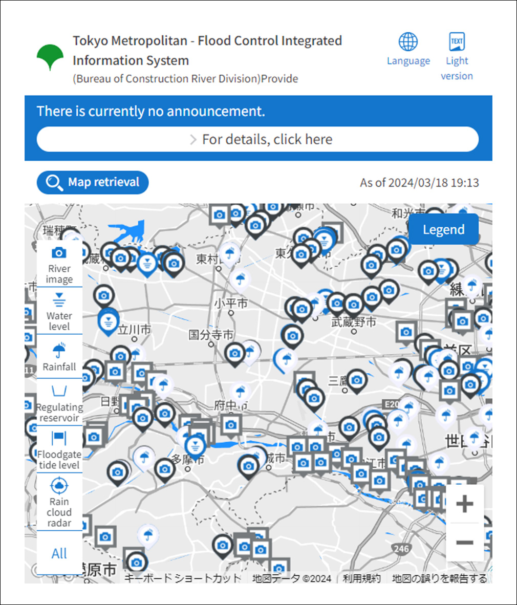
Top page
The top page displays information on rainfall, river water
levels and floodgate tide levels, river camera installation
locations, and weather information such as warnings, alarms and
special alarms.
Selecting an area and a municipality will display the
rainfall and river water level information and the river camera
installation locations in that area.
flood forecast river information, water level well-known river
information, and storm surge flooding information
Display the flood forecast river information, water level well-known
river information, and storm surge flooding information announced in
Tokyo.
Clicking the blue- or red-banded button at the top of the
screen will display more information.
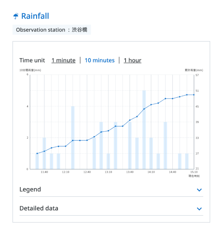
Rainfall information
Selecting an icon of the rainfall observatory will display
the details page.
The 10-minute display on the initial screen of the rainfall
graph shows the history of the past four hours from the displayed
time.
When 1 minute is selected on the rainfall graph, the
history of the past 24 minutes from the displayed time is
displayed.
When 1 hour is selected on the rainfall graph, the history
of the past 24 hours from the displayed time is displayed.
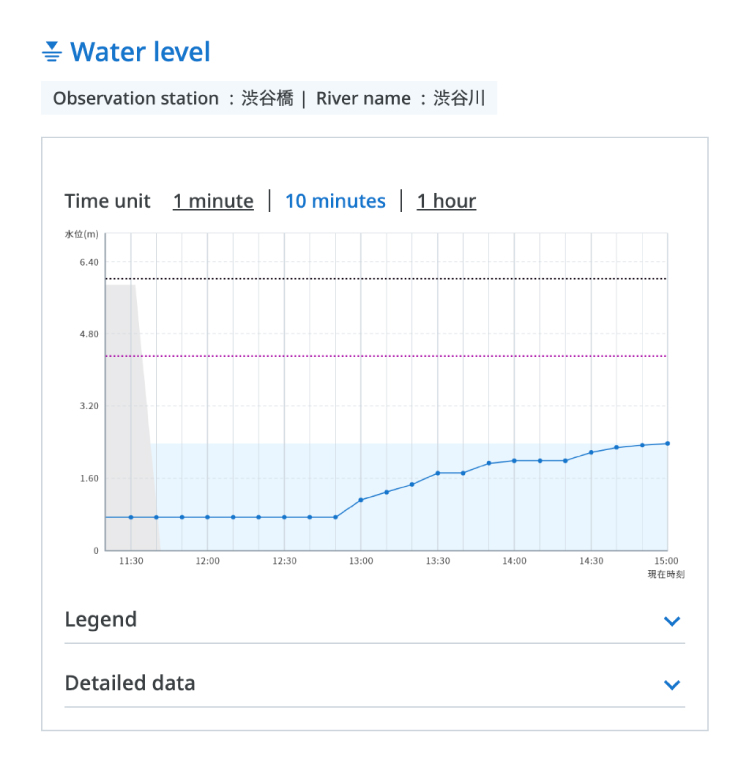
Water level information
Selecting the icon of the water level observatory will
display the details page.
The 10-minute display on the initial screen of the water
level graph shows the history of the past four hours from the
displayed time.
When 1 minute is selected on the water level graph, the
history of the past 24 minutes from the displayed time is
displayed.
Since the cross section of the river is a schematic
representation, it differs from the actual cross-sectional
situation.
River camera information
Selecting an icon showing the river camera installation
location will display the details page.
On the river image screen, you can select and display
images from the past 24 hours by button operation, etc.
The shooting range and location of river images are subject
to change due to equipment inspections, flood prevention
activities, etc.
If there is a video page button on the river image screen,
selecting the "Video Page" will open the live video page available
on YouTube.
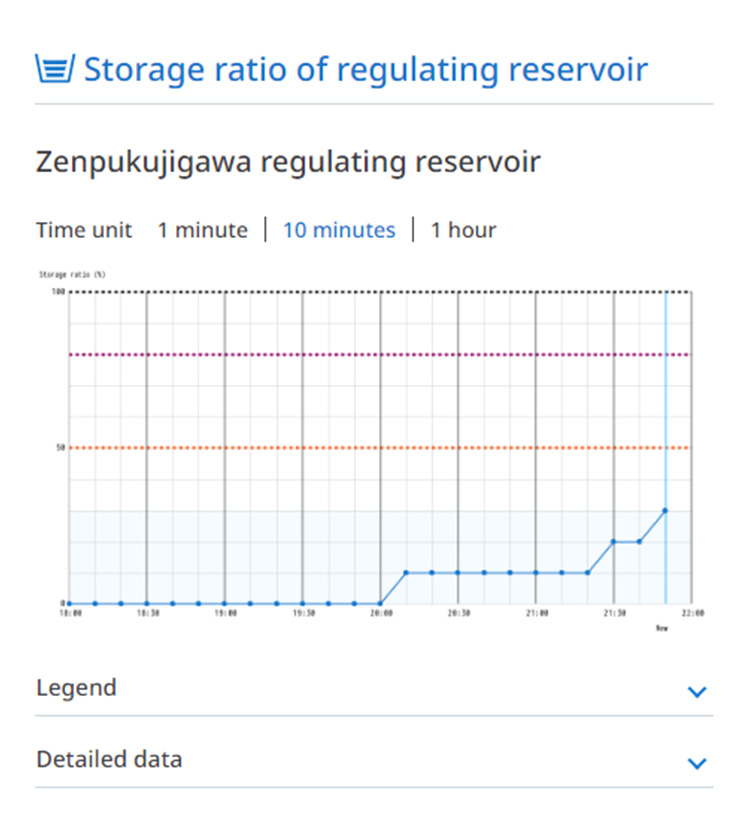
Reservoir information
The inflow into the regulating reservoir mainly contributes to lowering of the river water level downstream from the regulating reservoir.
In the event of a heavy rainfall, please follow evacuation information from the local government and take appropriate evacuation actions by referring to river flooding and water level information.
Stored water is promptly drained to prepare for the next rainfall while checking river, weather and other conditions.
Storage ratio and storage start time are provisional values.
In the system, the time when the prescribed storage ratio set for each regulating reservoir is exceeded is expressed as the storage start time.